On this page
Closed consultation

Submit feedback to
James
Costa
Inbound Aviation Pty Ltd
An airspace change proposal is to be submitted for two danger areas to be added to Aeronautical Information Package (AIP) within the vicinity of Mangalore Airport.
The issue
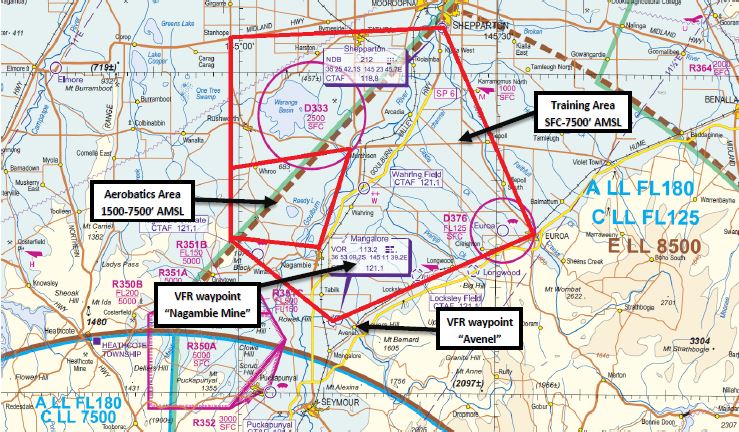
The Mangalore Airport Training Area boundaries are described in the ERSA, however have no graphical representation on navigational charts (such as the Visual Navigation Charts (VNC) or En-Route Chart (ERC)).
This means that airspace users who aren't familiar with the area may not be aware of the various types of VFR, IFR and aerobatic training being conducted within this area unless they read the En Route Supplement Australia (ERSA) FAC information for Mangalore Airport.
Purpose
The airspace above and surrounding Mangalore Airport (YMNG) is shared by a variety of light aircraft traffic within Class G airspace, including aircraft conducting IFR approach training utilising the Mangalore VOR, aircraft transiting the area enroute to/from airports in within the Melbourne area (such as Essendon and Moorabbin) as well as VFR flight training (including aerobatics) originating from Mangalore Airport itself.
Proposal
It is proposed that two Danger Areas and two VFR Waypoints be added to AIP Publications (including navigational charts) to advise users of this airspace of the various flight training activities being undertaken within the vicinity of Mangalore Airport and the surrounding area.
These being:
- a Danger Area for the training area boundary from SFC to 7500' (see lateral boundaries attached)
- a designated 'Aerobatics Area' within this Danger Area from 1500' to 7500' - similar to the one depicted in Moorabbin Airport's Training Area (D315)
- the addition of two VFR reporting points "Nagambie Mine" and "Avenel" as mentioned in the ERSA (these are currently uncharted, but utilised by our training aircraft to remain clear of aircraft using the Mangalore VOR for IFR training).
Enlarge image
Mangalore map