On this page
Closed consultation

Submit feedback to
ADF Airspace
Department of Defence
The previous consultation is cancelled and is amended in accordance with this update due to change of basing location to Croker Island vice Maningrida. Joint Airspace Control
Cell (JACC) requests feedback on proposed temporary restricted area (TRA), temporary Military operating areas (TMOA) and associated procedures for an Arnhem Coast military activity.
The issue
This proposal notes the following key issues:
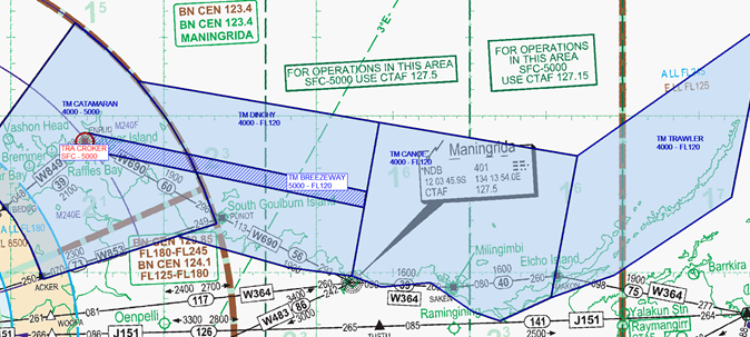
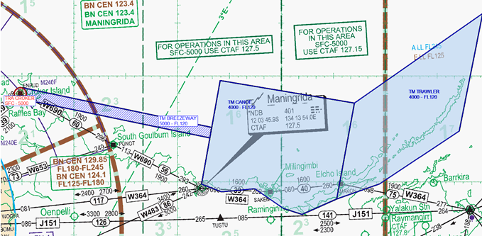
- Airspace associated with TMOA ‘CATAMARAN’, TMOA ‘DINGHY’, TMOA ‘CANOE’ and TMOA ‘TRAWLER’ over the Arnhem Land Coast from 1 September – 13 December 2025 remains unchanged.
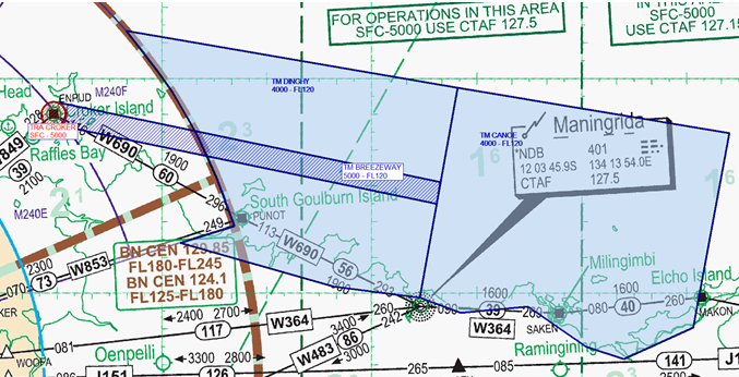
- TRA associated with basing location has changed significantly. TRA ‘CROKER’ replaces previous TRA ‘BARRA and TRA ‘MUNDI’. TRA ‘BREEZEWAY’ has changed completely to enable access to TMOA in the event TMOA ‘CATAMARAN’ and M240EF are not required.
- Impact to air routes is expected with some vertical levels not available during TMOA activations.
- The conditional status of the proposed TRA will be RA1, transit will be available with short delays.
- Transit of the proposed TMOA will not be approved except for aircraft experiencing an in-flight emergency or those with priority status engaged in preservation of life or property operations (i.e. medical evacuation (MEDEVAC), search and rescue (SAR) and flood and fire relief (FFR)).
Purpose
Elements of the Australian Defence Force (ADF) will be conducting a military activity along the Arnhem Coast operating from Croker Island airfield (YCKI).
Two TRA and four TMOA are proposed to safely segregate civil aircraft from the military flying activities.
Proposal
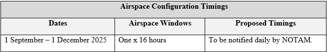
Aircraft will be operating from Croker Island airfield into areas along the Arnhem coastline. TRA ‘CROKER’ will be established at Croker Island airfield to enable aircraft to climb for operations in TMOA ‘CATAMARAN’ and overlying permanent airspace M240EF. TRA ‘BREEZEWAY’ will be established in conjunction with TRA ‘CROKER’ to enable aircraft to transit from Croker Island to other TMOAs in the event TMOA ‘CATAMARAN’ and M240EF are not required. It is expected only two TMOA will be activated at any one time. The activation period will be a sliding 16 hour block per day with timings notified by NOTAM.
Diversion Routes: Diversion routes will not be published, as sufficient levels are available above and below the airspace blocks to safely facilitate regular traffic patterns in the area.
Access to Airspace: A Defence mobile air operations team (MAOT) will be based at Croker Island to facilitate access to TRA ‘CROKER’. Procedures and contact details will be advised in AIP SUP.
Darwin air traffic control will provide advice and facilitate access to TMOA ‘CATAMARAN’ in accordance with extant procedures applicable to M240EF.
Transit of TRA will be delayed for up to four twenty minute periods per day. Otherwise, unrestricted transit can be expected of TRA (not TMOA).
During NOTAM activation periods, access by non-military aircraft to TMOA will generally not be available except for:
- Aircraft with a declared emergency, or
- Aircraft participating in operations for the preservation of life or property (SAR, MED, POL or FFR).
Airspace Configuration


Temporary Airspace Dimensions
YBBB/TRA ‘CROKER’ (new airspace and location)
Conditional Status: RA1
Military Flying
Lateral Limits: A circle radius 3.5NM centre 110955S 1322902E
Vertical Limits: SFC – 5000
Hours of Activity: NOTAM
Controlling Authority: DEFENCE JACC
YBBB/TM ‘BREEZEWAY’ (new airspace dimensions and location)
Military Flying
Lateral Limits: 110626S 1323012E – 112846S 1341930E – 113450S 1341828E – 111256S – 1323045E then along the counter clockwise arc of a circle radius 3.5NM centre 110955S 1322902E – 110626S 1323012E
Vertical Limits: 5000 – FL120
Hours of Activity: NOTAM
Controlling Authority: DEFENCE JACC
YBBB/TM ‘CATAMARAN’
Military Flying
Lateral Limits: 112050S 1314257E – 102414S 1322511E then along the clockwise arc of a circle radius 150.00 NM centre 122524S 1305423E (DN/DME) – 114101S 1332040E – 120220S 1321238E then along the counter clockwise arc of a circle 80.00 NM centre 122524S 1305423E (DN/DME) – 112050S 1314257E
Vertical Limits: 4000 – 5000
Hours of Activity: NOTAM
Contact: DEFENCE JACC
YBBB/TM ‘DINGHY’
Military Flying
Lateral Limits: 114549S 1330512E – 114101S 1332040E then along counter clockwise arc of a circle radius 150.00NM centre 122524S 1305423E (DN/DME) – 104630S 1324941E – 110221S 1342424E – 120104S 1341340E – 115756S 1334902E – 114549S 1330512E
Vertical Limits: 4000 – FL120
Hours of Activity: NOTAM
Contact: DEFENCE JACC
YBBB/TM ‘CANOE’
Conditional Status: RA2
Military Flying
Lateral Limits: 110221S 1342424E* – 111505S 1354208E – 120925S 1353150E – 121813S 1351153E – 121445S 1350106E – 120336S 1344434E – 120521S 1342516E – 120104S 1341340E* – 110221S 1342424E*
Vertical Limits: 4000 – FL120
Hours of Activity: NOTAM
Contact: DEFENCE JACC
*Indicates an amended lateral/long coordinate
YBBB/TM ‘TRAWLER’
Conditional Status: RA2
Military Flying
Lateral Limits: 120925S 1353150E – 111505S 1354208E – 102417S 1365612E – 113101S 1364242E – 120046S 1355638E – 120925S 1353150E
Vertical Limits: 4000 – FL120
Hours of Activity: NOTAM
Contact: DEFENCE JACC
CONCLUSION
The airspace configurations, dates and timings notified above represent the most up to date information on these activities. The proposed airspace windows notified are subject to amendment pending any feedback received or operational requirements from Defence. Any significant changes determined prior to the closure of the consultation window will be notified by a supplementary Aviation State Engagement Forum (AvSEF) publication. Final dates and timings will be notified by publication of an AIP SUP.
AvSEF members are invited to provide feedback by email to the Joint Airspace Control Cell (adf.airspace@defence.gov.au) by 28 July 2025.