On this page
Closed consultation

Submit feedback to
Kailash
Willis
NPWS
To seek feedback from other airspace users on potential impacts of a planned aerial shooting operation for the control of feral animal by the New South Wales (NSW) National Parks and Wildlife Service (NPWS).
The issue
NPWS is planning an aerial shooting program within the Shoalhaven and Illawarra-Highlands section of NPWS South Coast branch.
Aerial shooting operations are planned in NPWS parks and reserves near Nowra restricted airspace from Monday 23 to Friday 27 March 2026.
Aerial shooting operations are conducted by NPWS Park Air or authorised contractors in a Squirrel B3 helicopter.
In order to reduce the potential impact on other stakeholders, the aircraft will only operate during daylight hours and below 3500 feet.
Proposal
In order to control feral animal populations, aerial shooting operations are conducted by NPWS Park Air in a Squirrel B3 helicopter.
The aerial shooting operations will be conducted within NPWS land tenure and specific adjoining private properties, near Nowra restricted air space, performing low flying operations that target pest animals. The crew consists of a Pilot, Navigator, Shooter and an on-ground Officer-in-Charge maintaining flight following for search and rescue purposes.
This operation is part of a long-term pest animal control program that has been taking place since 1984 using highly trained shooters that are part of the Feral Animal Aerial Shooting Team (FAAST) staff.
Pest control operations will not be undertaken within the Nowra HMAS Albatross restricted airspace as pest animals being targeted are further to the west in Morton National Park and Bungonia State conservation area.
Flights will commence at first light and occur throughout the day until last light. While operations will primarily target times of peak pest animal activity operations may be conducted at any time of the day.
Please see the maps below:
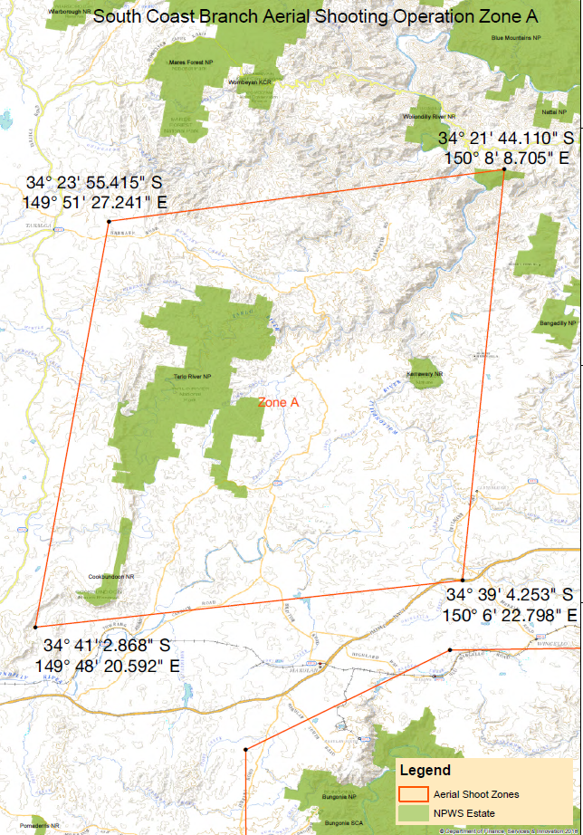
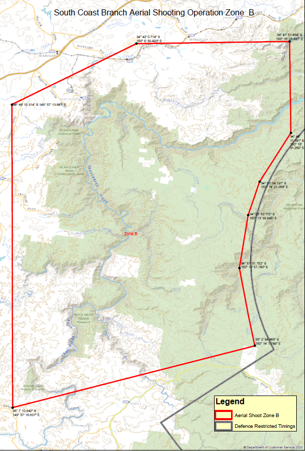

As with previous operations NPWS intends to apply for a Temporary Danger Area (TDA) or Notice to Airmen (NOTAM) for the areas outlined in the above maps for these dates.