On this page
Closed consultation

Submit feedback to
Andrew
Young
UNSW School of Aviation
Flying schools are seeking a Danger Area on aeronautical charts, in recognition of increased training activity and to reduce related safety risks.
The issue
The location of the new Western Sydney International Airport (WSI) and its associated airspace will remove or greatly reduce current Flying Training Areas (FTAs) in the Sydney Basin, most notably to the west of Bankstown Airport.
As a result, flying training schools at Bankstown Airport intend to move the bulk of their training activity from the current FTAs to a new FTA in the Sydney Basin, south of Bankstown Airport and Camden Airport (“Southern Training Area”).
The expected volume of displaced training activity from current FTAs to the southern training area is significant. According to the WSI Environmental Impact Statement (EIS), released in 2024, visual flight rules (VFR) flight and flying training activity over the WSI site and Control Zone, in March 2019, included 1605 departures, 2087 arrivals and 816 circuit operations.
The EIS estimated that in 2019 there were about 175 flight movements a day associated with training aircraft from Bankstown Airport accessing existing FTAs in the Sydney Basin. An estimated 75 per cent of those movements – or more than 130 movements a day – would relocate to the residual and proposed Southern Training Area, according to the EIS.
Purpose
Flying school operators at Bankstown Airport and Camden Airport are seeking to establish a Danger Area marked on aeronautical charts, in recognition of increased flying training activity in that area and to reduce related safety risks for all airspace users.
Proposal
CASA designates a Danger Area where an activity in that area is considered to pose a potential danger to aircraft. Danger Areas warn airspace users about hazardous activities, such as flying training, and the need to maintain a high level of vigilance when using or transiting through such areas.
The designation of a Danger Area is common practice for FTAs in the Sydney Basin. Such designations do not permit or authorise flying training activity. Rather, a Danger Area recognises activities already occurring in that area and helps reduce related safety risks for all airspace users by raising awareness.
The location of WSI and its associated airspace – which will come into effect in mid-2026 – will remove or greatly reduce current FTAs in the Sydney Basin, most notably to the west of Bankstown Airport. The bulk of that activity is expected to move to the new Southern Training Area, south of Bankstown Airport and Camden Airport. This expected volume of flying training activity in the Southern Training Area creates potential hazards and dangers for other users of that airspace. Hazards include inconsistent flight paths and altitudes within the Southern Training Area, due to the requirement for new pilots to practise variable flight activities, such as spins, stalls and steep turns.
The designation of a Danger Area to represent the new Southern Training Area is required to raise awareness of hazards and the need for aircraft in that airspace to take appropriate precautions to reduce safety risks. This requirement was affirmed in the WSI EIS, which stated: “As the existing FTAs in the Sydney Basin are declared as ‘Danger Areas’ there is an expectation that CASA may declare the proposed future FTAs similarly.”
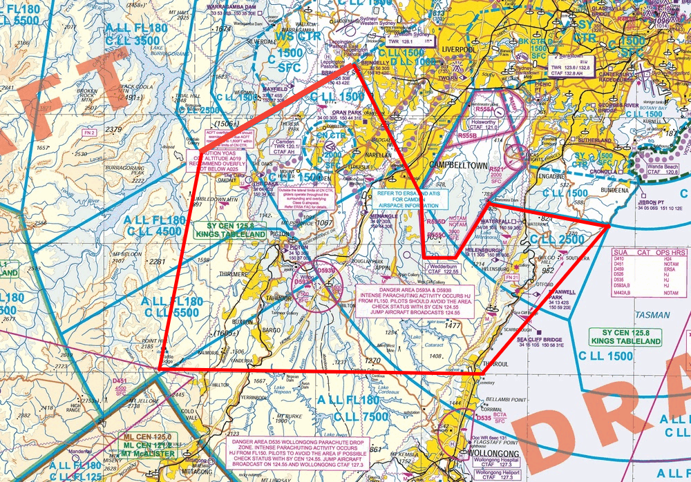
The boundaries of the proposed Danger Area are detailed below and align with the proposed boundaries of controlled airspace. It is expected that all parts of the proposed Danger Area will be used for flying training activities. The proposed Danger Area stretches east to the coastline, which would be used by Bankstown Airport operators who opt to depart via the proposed Southeast VFR Corridor, which is subject to a separate process being led by CASA. The boundaries of the proposed Danger Area were selected to provide enough coverage to encapsulate the flying training activities of most operators in the Sydney Basin, providing awareness and reducing safety risks and hazards for all airspace users.
Horizontal limitations
- 33°56'07"S 150°43'45"E
- 34°03'16"S 150°29'24"E
- 34°19'50"S 150°25'05"E
- 34°19'51"S 150°55'47"E
- 34°08'18"S 151°07'23"E
- 34°06'34"S 150°56'09"E
- 34°10'59"S 150°52'59"E
- 34°11'00"S 150°49'58"E
- 34°06'05"S 150°49'19"E
- 33°56'07"S 150°43'45"E
Vertical limitations
Up to CTA.