On this page
Open consultation

Submit feedback to
National Airspace Management Office
-
Department of Defence
The Department of Defence National Airspace Management Office (NAMO) requests feedback on the establishment of a danger area north of the Pearce Military airspace to support Defence flying training outcomes.
The issue
- Proposed establishment of a permanent danger area (previously activated as Temporary Danger Area Pickle) to extend D193 when required to support low level flying training.
- The accumulation of low flying hazards (mining activity and wind-farm developments) in D193 have restricted low level flying training to the Eastern portion of D193 where airspace can become relatively congested around Moora township and aerodrome (YMRO).
- Proposed danger airspace volume extending to 135DME Perth bounded by the PH 019VOR radial on the East and Brand Highway on the West. Airspace designed to avoid the network of low-level visual flight rules VFR transit corridors around M147 (Lancelin Air Weapons Range), and population centres/rural settlements which are more abundant near the coast.
Purpose
The NAMO requests feedback on the establishment of a danger area north of the Pearce Military airspace to support Defence flying training outcomes.
Defence seeks to raise awareness and increase safety for the aviation community with a danger area proposed to support low flying training outcomes for the Royal Australian Air Force. In 2025, Defence consulted with industry on temporary danger area (TDA) Pickle. This airspace has been activated on numerous occasions since and as such is proposed to become a permanent danger area. This proposal is to publish the airspace formally known at TDA Pickle as a permanent danger area.
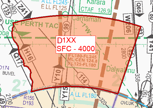
Proposed DAH Amendment
YMMM/D1XX
Military Flying
Lateral Limits: 294618S 1151543E – then along the clockwise arc of a circle radius 135.00NM centre 315642S 1155734E (PH/DME) – 294831S 1164749E – 303117S 1163119E – then along the counter clockwise arc of a circle radius 90.00NM centre 315642S 1155734E (PH/DME) – 303000S 1152836E then north along the Brand Highway – 294618S 1151543E
Vertical Limits: SFC – 4000
Hours of Activity: NOTAM
Controlling Authority: 453SQN Pearce Flight Commander
Map Depiction
Related links
Proposed Temporary Danger Area 'PICKLE' 2026 | Aviation State Engagement Forum