On this page
Closed consultation

Submit feedback to
Alysha
Poyner
RAAF
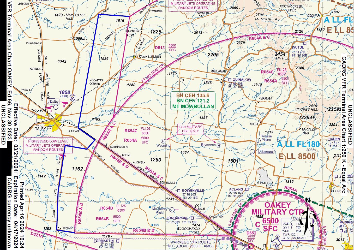
Australian Army Aviation Training Centre (AAvnTC) utilise R654/D613 for helicopter training. Due to restrictions they also fly West of R654 to Dalby and propose a Danger Area (DA) to advise on their operations.
The issue
- The Western flat land areas of the Oakey Restricted airspace have become increasingly constrained. This is exacerbated over the years by the loss of the South Western Restricted airspace as part of the Wellcamp airspace.
- Low level Army military flying operations beyond the Western boundaries of R654A & R654B, into Class G airspace, do occasionally occur.
- The extension of D613 or a new DA to include the expanded training areas to the West, will only help inform civil traffic in Class G that military aircraft could be operating in the lower levels of those the area.
- There is no intent of transitioning this airspace into restricted airspace.
Purpose
To inform Aviation State Engagement Forum (AvSEF) users of an updated proposed permanent extension of D613 or creation of an additional DA due to increased military flying between R654 and Dalby.
Proposal
The AAvnTC utilises the airspace and land surrounding Oakey for both basic and advanced military helicopter flying training of aircrew. Predominately, helicopter operations are at low level (below 1,000 feet above ground level) for this training and also use approved landing sites throughout the areas. The Republic of Singapore (RSAF) also operates helicopter in the same areas.
The Western flat land areas of the Oakey Restricted airspace have become increasingly constrained by urban sprawl and noise sensitive agriculture operations (ie. beef feedlots). This has been exacerbated over the years by the loss of the South Western Restricted airspace as part of the Wellcamp airspace development plan. The high use of these Western areas for flying training is attributed to the generally better weather (compared to the Eastern areas which are often limited due cloud), and the ease of access. Operations beyond the Western boundaries of R654A & R654B, into Class G airspace does occasional occur. In order to reduce the congestion and improve training outcomes in the Western training areas, formally expanding operations use further West is desirable.
Much like the Northern and Eastern training areas that extend beyond R654A (23 nautical miles radius of Oakey) into designated DA (D613), these new proposed / expanded DAs will remain Class G airspace. As such, transiting civil Visual Flight Rules (VFR) traffic is expected. The previous 20 to 30 years of operations of the Northern and Eastern DAs has not been problematic.
The extension of D613 or a new DA to include the expanded training areas to the West will only help inform civil traffic in Class G that military aircraft could be operating in the lower levels of those the area. The height of the DA is proposed up to 3,500 feet above mean sea level (AMSL), which is approximately 2,000 feet above ground level.
AAvnTC is requesting either a new DA in line with the boundaries below, or an extension of D613. Additionally, it is acceptable for D613s height to be reduced to 3,500 feet AMSL.
DA Request YBBB/DXXX OAKEY Military Flying Lateral Limits:
27 23 31 S 151 18 29 E
27 23 09 S 151 16 08 E
27 17 57 S 151 16 18 E
27 13 36 S 151 17 08 E
27 14 01 S 151 20 00 E
27 12 58 S 151 21 00 E
27 11 38 S 151 18 54 E
26 58 47 S 151 21 29 E
26 59 00 S 151 25 28 E
Vertical Limits: SFC - 3500
Hours of Activity:
Monday to Thursday: 2200 to 1330
Friday: 2200 to 0630 EXC PH OT by NOTAM
Controlling Authority: FLTCDR 452SQN OAKEY