 Aviation State Engagement Forum
On this page
Open advisory

Submit feedback to
Justyn
Money
Australian Defence Force
Defence is conducting GNSS Jamming effects at Jervis Bay airfield over the period 14 to 25 September 2026 between 8am-5pm.
The issue
- GNSS Jamming effects are difficult to constrain within the bounds of YJBY and adjacent East Australian Exercise Area (EAXA)
- GNSS Jamming effects may impact multiple air routes.
Purpose
Defence is advising the aviation community on the conduct of GNSS Jamming at Jervis Bay airfield to support Defence trial objectives.
Proposal
Defence is conducting GNSS Jamming effects at Jervis Bay airfield over the period 14 to 25 September 2026. These effects are occurring to inoculate ADF elements to the realities of operating with degraded GPS. These effects include jamming the following radiofrequencies:
- Radio Navigation Satellite System (RNSS) GPS L1 and L2 (affecting positioning and timing synchronisation)
Summary of Risk Controls
Defence has implemented a number of controls to reduce the collateral impact and risk of GPS jamming effects to non-Defence users in the vicinity of the activity.
Proactive Controls
- There will be no spoofing of GNSS
- This means that availability of GPS may be reduced for receivers in the direction of transmission, but integrity of GPS signals will not be impacted.
- Defence has planned the activity to use directional antennas, pointing away from major town centres/cities
- The planned antenna pointing directions intentionally avoid Sydney, Canberra and Wollongong.
- Jamming antennas will be pointing horizontal or towards the ground, to minimise inadvertent effects to the airspace.
- Conservative estimation of impact
- As discussed in further detail in this Advisory, Defence has a number of conservative assumptions made when modelling/predicting the impacted area from this activity, in accordance with practice from international aviation safety bodies. More realistic estimates are also provided, which are a more realistic prediction of effects expected to be felt by users closer to the GPS jammer.
- Operations during daytime only
- Defence will only conduct jamming for this activity during daylight hours
- Jamming effects will be restricted to achieve operational objectives only.
- Jamming time will be limited to only when directly when conducting the activity.
- There is active engagement between Defence GNSS Jamming Operators and ATC in order to coordinate and minimise disruption.
Reactive Controls
- Defence has mature CEASE BUZZER procedures which can be enacted if there is a risk to Safety-Of-Life
- Defence will implement at least 3 different communication bearers so that CEASE BUZZER calls can reach the GPS jammer operators in a timely and reliable manner to quickly cease operations if needed.
- If required, upon consultation and appropriate reporting, Defence can seek to reorientate the transmitting antennas to reduce unintended effects to airspace users e.g. if another area needs to be avoided beyond Sydney, Canberra, Wollongong, then Defence can look to change antenna pointing directions.
Further Details
GNSS jamming
There will be no spoofing of GNSS.
GNSS jamming is assessed to be of greatest impact to commercial and civil aviation. GPS testing is scheduled as follows and may result in interrupted or unavailable GPS signal.
GNSS jamming may occur at medium power, Monday to Friday throughout the period 14 – 25 September 2026 during selected periods between the hours of 2200 Z and 0700 Z (0800 AEST to 1700 AEST), with NOTAMs released NLT 48 hours prior with the specific jamming windows.
NOTAMs will be issued for the FIR and for potentially affected airfields around the jamming activity. NOTAMs will describe both Defence anticipated effects and the maximum potential effects.
Duration: Timings described in this AvSEF are indicative only and are subject to change, review NOTAMs for confirmed timings.
The FIR NOTAM below represents the maximum limits under which a GNSS receiver may experience difficulty re-acquiring GNSS position in the event that the receiver does not have a position lock. This AVSEF provides further information to identify areas where Jamming may cause a GNSS receiver to lose track.
FIR NOTAM:
GNSS CAPABILITY MAY BE SUBJ TO INTRP DUE INTERFERENCE WI 1000FT AGL: LATERAL LIMITS: 344138S 1513631E - 345906S 1513958E - 350939S 1512330E - 352651S 1504213E – 355532S 1501322E 353635S 1494834E - 350730S 1500940E - 343224S 1500254E - 343016S 1503920E - 343502S 1511336E - 344138S 1513631E 4800FT AMSL: LATERAL LIMITS: 342737S 1521137E - 350830S 1522607E - 360908S 1504714E - 361306S 1494357E - 354008S 1493921E - 341744S 1494953E - 341148S 1504158E - 343452S 1511416E - 342737S 1521137E 10000FT AMSL: LATERAL LIMITS: 340036S 1491530E - 344406S 1491133E - 352558S 1491908E - 355816S 1490159E - 364914S 1492027E - 363345S 1503635E - 350445S 1531825E - 342731S 1521031E - 335930S 1504105E - 334321S 1495020E - 340036S 1491530E CTC MELBOURNE CENTRE ATC TO REQ CEASE TRANSMISSION OF JAMMING SIGNAL IN THE CASE OF GPS UNAVAILABILITY AFFECTING SAFETY OF FLIGHT F)SFC G)FL300 MON TO FRI FROM 09 142200 TO 09 250700
ABOVE REPRESENTS ANTICIPATED MAXIMUM INTRP RADIUS DETERMINED THROUGH PRACTICAL EXPERIENCE AND TESTING. HOWEVER SOME GNSS RECEIVERS MAY EXPERIENCE INTRP WITHIN THE FOLLOWING RADIUS
GNSS AVAILABILITY MAY BE SUBJ TO INTRP DUE INTERFERENCE WI 50FT AGL: 40NM RADIUS PSN 350845.72S 1504146.48E 4000FT AGL: 99NM RADIUS PSN 350845.72S 1504146.48E 10000FT AMSL: 142NM RADIUS PSN 350845.72S 1504146.48E 15000FT AMSL: 167NM RADIUS PSN 350845.72S 1504146.48E 25000FT AMSL: 207NM RADIUS PSN 350845.72S 1504146.48E 40000FT AMSL: 254NM RADIUS PSN 350845.72S 1504146.48E CTC MELBOURNE CENTRE ATC TO REQ CEASE TRANSMISSION OF JAMMING SIGNAL IN THE CASE OF GPS UNAVAILABILITY AFFECTING SAFETY OF FLIGHT F)SFC G)FL300 MON TO FRI FROM 09 142200 TO 09 250700
Anticipated Airfield NOTAM.
- Additional NOTAM will be issue for individual Airfields where GNSS Jamming will impact approach/departure.
The NOTAM previewed may change with little or no notice. Pilots are advised to check NOTAMs frequently for possible changes prior to operations in the area. NOTAMs will be published at least 48 hours in advance of any GPS tests.
Pilots are encouraged to report anomalies to Air Traffic Services (ATS) in accordance with CASA’s published guidance on “Recognising, Mitigating and Adapting to GNSS Interference” . As required, ATS will coordinate with Defence test controllers in accordance with the Manual of Air Traffic Services (MATS) section 5.1.11.
JAMMING ACTIVITY DETAILS
Defence is planning to conduct a variety of GNSS JAMMING effects at YJBY over the period 14 to 25 September 2026.
Jamming will be conducted using directional antennas with a 30 degree beamwidth set at a zero degree elevation to reduce the effects on the wider aviation community. Intended Jamming will be conducted along up to three directions from the jamming site with those directions being:
- 100 degrees True (T)
- 220 degrees T, and
- 325 degrees T
The directions listed above have been selected to reduce impact to airfield approaches for the larger airfields around the jamming locations. The list of airfields considered for potential impact are:
- Nowra (YSNW)
- Canberra (YSCB)
- Moruya (YMRY)
- Cooma (YCOM)
- Goulburn (YGLB)
- Shellharbour (YSHL)
- Sydney Kingsford Smith (YSSY)
There will be times when only one jammer is in use and the direction for single jammer operation will be 100 degrees True, negating any potential impact to airfields.
Jamming modelling
Modelling has been conducted using two methods:
- Without Body (fuselage) masking (most conservative)
- With body masking (Defences expected effects)
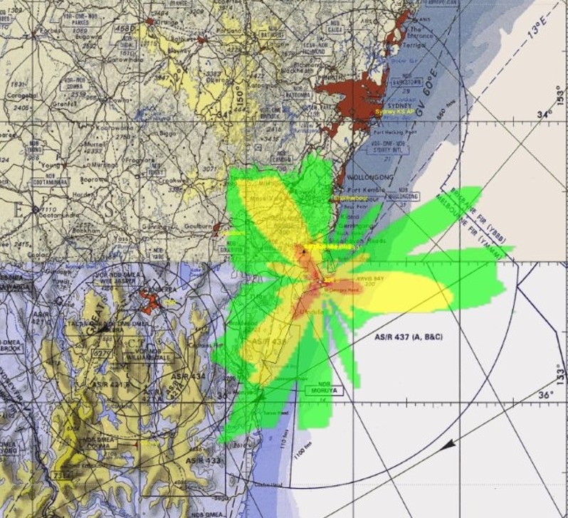
| Colour | Jamming power level received (dBm) | Jammer to signal (J/S) ratio (dB) | Notes |
| Green | -94.5 to -104.5 | 24 to 34 | A J/S of 24 dB can deny a receiver from acquiring GPS signals, i.e. at power up |
| Yellow | -84.5 to -94.5 | 34 to 44 | Slightly stronger jamming, no acquisition if GPS is not already being tracked |
| Orange | -74.5 to -84.5 | 44 to 54 | A J/S of 44 dB can deny a GPS receiver from maintaining tracking of GPS signals and cause the receiver to cease outputting a position |
| Red | -64.5 to 74.5 | 54 to 64 | Denial of civilian GPS at this and stronger jamming levels |
No body masking modelling
Modelling of the jamming effects indicates that the greatest effect, potentially causing the loss of GPS tracking in the receiver, will occur between altitudes of 3700 ft MSL and 10000 ft MSL. Within these altitudes the jamming effect will be less than 30 nm along the jamming directions as shown in Image 1.
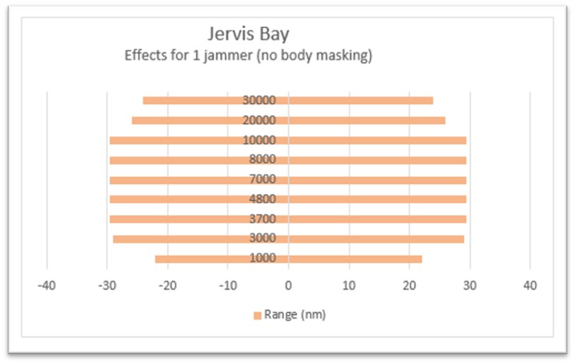
Below 3700 ft MSL effects reduce in range with decreasing altitude and above 10000 ft MSL the effects reduce in range with increasing altitude. An example of the modelling effects is in Image 2 below. Image 2 is for jamming at 4800 ft MSL and shows the decreasing jamming strength with range from the jammer in each of the three directions. The outer boundary of the orange area denotes where a receiver, without any body (fuselage) masking may be denied GPS signal reception (knock-off) under ideal conditions. The NOTAMs will be written based on no body masking modelling and as such are conservative.
Body masking modelling
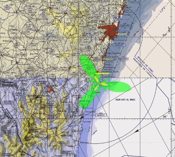
Image 3 shows jamming with body (fuselage) masking at 4800 ft MSL and shows the decreasing jamming strength with range from the jammer. Effects that account for body masking are the effects the Department of Defence expects to occur. This image shows that with body masking, an aircraft’s GPS receiver will not lose GPS signals at this altitude. Using the body masking modelling method, a receiver will not lose GPS unless flying within 2 nm of overhead the jamming location at 1000 ft MSL.
Modelling of jamming effects with relation to potentially affected airfields
Canberra (YSCB)
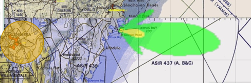
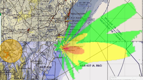
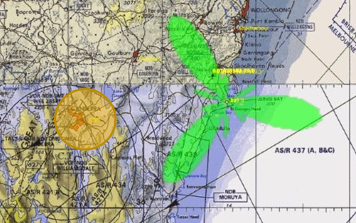
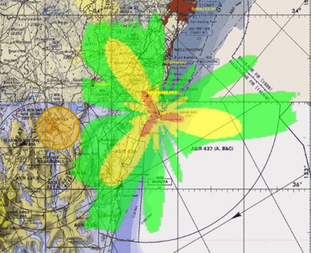
The GNSS approach for Canberra starts at 25nm at 7000ft MSL. The images below shows the jamming effects at 7000 ft MSL for a single jammer pointed 100 degrees true and three jammers pointing 100, 220 and 325 degrees true. The orange circle around Canberra denotes a 25 nm radius from the airfield. Modelling also shows the difference between body masking and no body masking. Once again, the yellow orange boundary is where a GPS receiver may lose GPS tracking (knock-off). The outside boundary of the green area is where a civilian GPS receiver may have difficulty re-acquiring GPS signals if position lock and track is not already established.
Expected effects on aviation operations
Aircraft operating within the notified area may, depending on range and altitude with respect to the jammer location, experience intermittent degradation or loss of GNSS-derived position, navigation and timing information during periods of jamming. Depending on aircraft equipment, operating environment and proximity to the activity, operators may observe navigation uncertainty, degradation of GNSS-dependent capabilities, or associated cockpit alerts and warnings. Operators should consider the availability of alternative navigation and contingency procedures when planning operations during notified periods. Defence will not conduct any spoofing of GNSS signals associated with these activities.
Safety and spectrum management controls
Defence has undertaken spectrum planning and technical analysis to minimise impacts on non-participating users while achieving essential training and trial outcomes. Proposed frequencies, bandwidths and transmission parameters are subject to Defence spectrum management processes and coordination arrangements as required. Activities will be supported by NOTAM publication, Air Traffic Services coordination and established cease-buzzer procedures.
Propagation of electromagnetic interference effects
The propagation of radiofrequency energy is influenced by a range of factors including transmission characteristics, aircraft altitude, terrain and atmospheric conditions. As a result, electronic attack effects may extend beyond the geographic boundaries of Jervis Bay airfield. Defence has sought to minimise the extent and duration of effects while achieving the required trial outcomes.
Potential operational impacts
Operators intending to conduct GNSS-dependent operations within the notified area during periods of activity should review applicable NOTAMs and assess the suitability of planned navigation, surveillance and operational procedures. The anticipated area of effect and activity periods will be promulgated through aeronautical information products.
Aeronautical information
Final coordinates, dimensions, altitudes and activity periods will be promulgated through approved aeronautical information products, including NOTAMs. Operators should consult current aeronautical information during operational planning and execution. The draft NOTAM included in this consultation is provided for awareness purposes and remains subject to refinement prior to publication.
Operational necessity
Contemporary military operations rely heavily on positioning, navigation, timing and communications systems. Training in and testing Defence capability in a degraded electromagnetic environment is necessary to ensure personnel, systems and procedures remain effective when those capabilities are disrupted. The proposed activities are designed to achieve these training and trial outcomes while applying appropriate safety, spectrum management and airspace risk mitigations.
Jamming Clearance
30 minutes prior to the conduct of radiating and commencing noise jamming, Defence will seek approval from the appropriate controlling ATS for YJBY. Once ATS has been notified of the intention to jam, ATS will provide approval or not for the activity. Upon granting approval, ATS will notify nearby airfields that jamming activity has commenced. Without ATS clearance jamming will not commence.
Cease Buzzer
Defence has arrangements in place to suspend GNSS jamming activities should an unexpected aviation safety concern be identified during actual transmission. This is referred to “cease buzzer”. Operators experiencing suspected interference should report the occurrence through their controlling ATS to enable assessment and coordination with Defence personnel. If ATS assess that safety is impacted they will contact Defence to advise of the requirement to cease buzzer. Specific cease-buzzer contacts and procedures will be promulgated through applicable NOTAMs, but operators should contact ATS for cease buzzer coordination. The cease buzzer procedure is a control mechanism to stop transmission in the event of interference and should not be utilised pre-emptively (i.e. it is not a control measure for when no interference is experienced).
Contact details During conduct of the activity 14 to 25 September, contact details regarding EMI LCDR Justyn Money and SQNLDR Paul Wilkinson: pntas.corro@defence.gov.au.