On this page
Closed consultation

Submit feedback to
Shridutt
Devagiri
Department of Defence
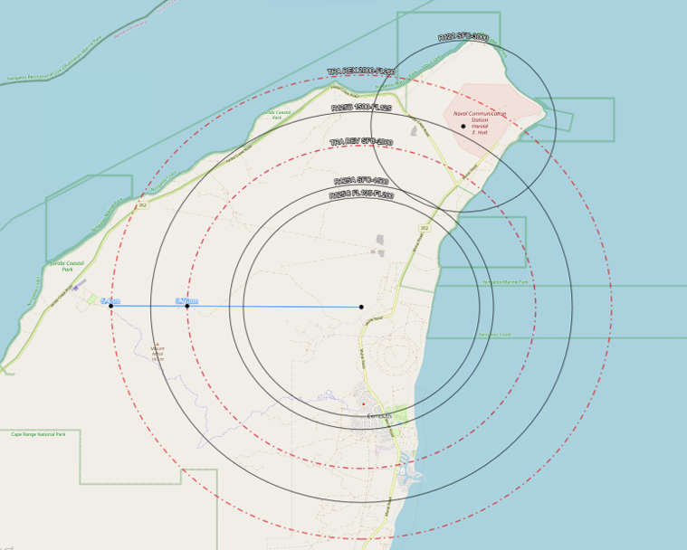
Proposed temporary restricted area (TRA) in the vicinity of (IVO) Learmonth Airport (YPLM) due to increased high intensity radiated field (HIRF) for system testing purposes. This TRA overlaps existing R125ABC and R122 SUAS areas.
The issue
Proposed TRA Date: From 1 August 2025 - 30 October 2025
Proposed: Small unmanned aircraft (SUA) Name and Status: YMMM/TRA DEV RA3
Lateral Limits: A circle radius 3.76 nautical mile (n mile) centred 215325S 1140708E
Vertical Limits: SFC – 2000
Hours of Activity: H24
Controlling Authority: XO 1SSU
Proposed SUA Name and Status: YMMM/TRA REX RA3
Lateral Limits: a circle radius 5.4 n mile centred 215325S 1140708E
Vertical Limits: 2000 - FL260
Hours of Activity: H24
Controlling Authority: XO 1SSU
Purpose
To consult local civil and industry stakeholders prior to implementing new TRAs in the vicinity of R125 and R122 to restricted airspace R125A/B and subsequently changing the affected IAP at Learmonth. These TRAs are required to protect aircraft from HIRF created by military radar operations.
Proposal
The purpose of this ACP is to change the lateral and vertical limits of restricted airspace IVO Exmouth, WA via a temporary airspace (TRA) change in the immediate term with the option to create a permanent airspace change for CY2026. These changes are required to protect aircraft from high intensity radiated fields created by military radar operations IVO Harold E Holt Defence Precinct (HEH).
The TRA is intended as two tiers.
TRA DEV: A circle radius 3.76 n miles centred 215325S 1140708E, from SFC-2000
TRA REX: A circle radius 5.4 n miles centred 215325S 1140708E from 2000-FL260
EXISTING RESTRICTED AIRSPACE STRUCTURE
|
SUA Name / Status |
Lateral Limits |
Vertical Limits (ft AMSL) |
Hours of Activity |
Controlling Authority |
|
YMMM/R122 North West Cape RA3 |
A circle radius 2NM 214900S 1140930E |
SFC - 3000 |
H24 |
MSCSPO NCS HEH |
|
YMMM/R125A Norther West Cape RA3 |
A circle radius 2.85NM 215325S 1140708E |
SFC - 1500 |
H24 |
XO 1SSU |
|
YMMM/R125B North West Cape RA3 |
A circle radius 4.55NM 215325S 1140708E |
1500-FL135 |
H24 |
XO 1SSU |
|
YMMM/R125C North West Cape RA3 |
A circle radius 2.55NM 215325S 1140708E |
FL135-FL200 |
H24 |
XO 1SSU |
PROPOSED STRUCTURE
|
Lateral Limits |
Vertical Limits (ft AMSL) |
Hours of Activity |
Controlling Authority |
|
|
YMMM/R122 North West Cape RA3 |
NO CHANGE |
NO CHANGE |
NO CHANGE |
NO CHANGE |
|
YMMM/TRA DEV RA3 |
A circle radius 3.76NM centred 215325S 1140708E |
SFC – 2000 |
H24 |
XO 1SSU |
|
YMMM/TRA REX RA3 |
a circle radius 5.4NM centred 215325S 1140708E |
2000-FL260 |
H24 |
XO 1SSU |
|
YMMM/R125A North West Cape RA3 |
NO CHANGE |
NO CHANGE |
NO CHANGE |
NO CHANGE |
|
YMMM/R125B North West Cape RA3 |
NO CHANGE |
NO CHANGE |
NO CHANGE |
NO CHANGE |
|
YMMM/R125C North West Cape RA3 |
NO CHANGE |
NO CHANGE |
NO CHANGE |
NO CHANGE |
IMPACTS ON AERODROMES and AIR ROUTES
Learmonth (YPLM)
Aeronautical Information Service - Air Force (AIS-AF) have assessed the proposed TRA and have found nil impact to current AIS-AF instrument flight procedures (IFP) at YPLM.
Uncertified Aerodromes IVO the proposed SUA
Yardie Aerodrome
Yardie aerodrome is located approximately 6.1 n miles west from the proposed centre of the SUA and approximately 0.85iles from the western boundary of the proposed lateral limit to TRA REX.
Yardie aerodrome caters for tourists to the coastal areas to the west of the Exmouth Peninsula who generally arrive by airline type aircraft into YPLM and then by light aircraft to/from Yardie aerodrome. Flight operations at Yardie are typically contained within 1 n miles of each runway threshold and can operate at a height of 1000 feet above ground level (AGL), beneath the lower limit of TRA REX.
Exmouth Aerodrome
Exmouth aerodrome is located approximately 8.9 n miles south of the proposed centre of all airspace and approximately 3.22 n miles from the southern boundary of R125B. It services the local community and provides for aeromedical evacuation in the event of a serious accident or illness occurring in the area. Exmouth aerodrome is located outside the 3 n miles assessment area, implementation of these TRAs are unlikely to have any impact on flight operations at Exmouth aerodrome.
Summary
Flight operations at Exmouth and Yardie aerodromes would not be adversely impacted by the proposed SUA.
IFR Air Route Impact
IFR air routes IVO the proposed TRAs converge on YPLM as a waypoint. These are published by Airservices Australia as a component of the AIP. Enroute charts high (ERC-H) contain the details of significant air routes used by transcontinental, inter-capital and international air traffic for flight operations above flight level 200 (FL). Enroute charts low (ERC-L) contain the details of air routes used by local aircraft up to and including FL200.
Q327
It is possible that aircraft travelling north on Q327 via YPLM to waypoint SOPAT may approach the TRA boundary if travelling between their expected OCA A LL of FL245 and FL260. It is recommended that IFR aircraft on Q327 are cleared elevate FL300 prior to YPLM to prevent incursions/airspace breaches.
Related links
https://www.avsef.gov.au/consultations/proposed-changes-r125ab-and-lear…