On this page
Closed consultation

Submit feedback to
Laphang
Chung
Aurecon Australasia Pty Ltd
Consultation with visual flight rules (VFR) route 4 users on their perspective of operational safety impact from the proposed location of meteorological mast 1 near Breton Bay, WA.
The issue
Due to the close proximity of one of the three masts proposed – mast 1 (31°10'8.01"S, 115°26'35.73"E) being only ~80 metres east of the VFR 4 lateral extents, the assessment recommended for consultation with aircraft operators regarding potential implications for flight operations because:
- VFR 4 boundaries are referenced from the coastline and is defined as a 2 nautical mile (NM) coastal route from surface to 2,000 feet (ft) above ground level (AGL) above mean sea level (AMSL) with south-bound traffic over water and north-bound traffic over land but not more than 2nm inland (due to restricted area R155B)
- North-bound pilots are to fly visually with reference from an undulating coastline
- North-bound pilots are to maintain situational awareness of south-bound aircrafts flying over water (which needs to maintain closely over the coastline due to danger area D198)
- Mast 1 is located just ~80m east of the VFR 4 lateral extent (inside R155B).
Purpose
Requests for aircraft operators feedback on a proposed 430 ft AGL (~700ft AMSL) meteorological mast near Breton Bay approximately 80m east of the visual flight route 4 (VFR 4) lateral extents.
Proposal
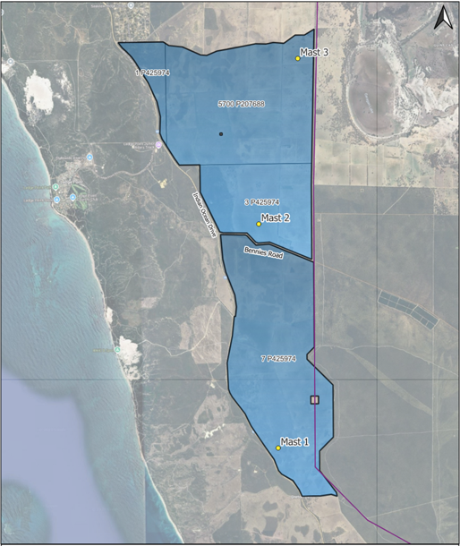
Three meteorological masts 430ft AGL (~700ft AMSL) are proposed at Breton Bay to collect local weather data (refer to Figure 1 for met masts locations).
The visual navigation chart (VNC) Perth indicates a VFR route 4, along the coast which extends to 2 NM in-land laterally from surface to 2,000ft AMSL, with north-bound traffic over land and south-bound traffic over water (refer to Figure 2).
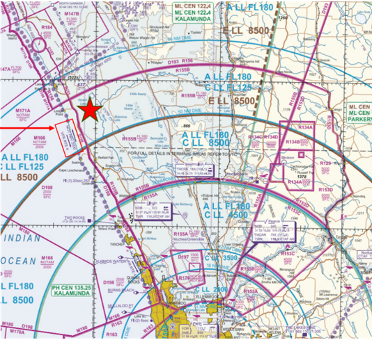
Preliminary aeronautical assessment concluded that all three meteorological masts are within the restricted area R155B and do not infringe upon VFR 4 airspace. It should be noted that the Department of Defence has been separately consulted on the impact to R155B.
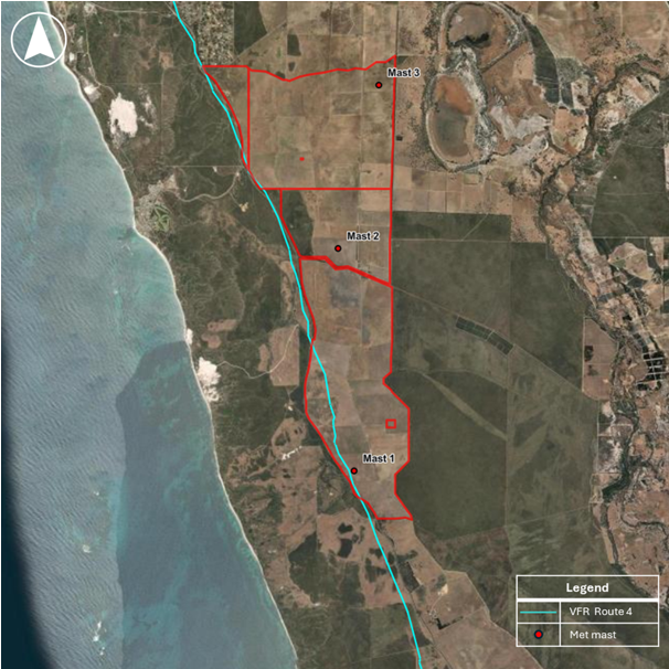
Mast 1 (31°10'8.01"S, 115°26'35.73"E) is assessed to be only ~80m east of the VFR 4 lateral extents (refer to Figure 3).
Requests for VFR route 4 users feedback on the proposed 430ft AGL (~700ft AMSL) Mast 1 to their operational safety.