 Aviation State Engagement Forum
On this page
Open consultation

Submit feedback to
Jason
Milne
Southern Launch
.
The issue
W-7 satellite re-entry to Koonibba Test Range, South Australia. The declaration of temporary restricted and danger areas to support safe separation during the re-entry activity. Airspace activation via NOTAM for approximately 60 minutes on one or more occasions between 1 December 2026 and 31 January 2027. NOTAMs will cover up to five successive contingency days, with the activation time moving forward by approximately 22 minutes per day. Refined activity dates and timings will be advised by an updated AvSEF Advisory Notice, following the satellite's launch in October 2026.
Purpose
Southern Launch is seeking feedback on the potential impacts of proposed TRAs and TDAs required to ensure safe separation between aircraft and the W-7 satellite during re-entry from orbit into the Koonibba Test Range in December 2026 to January 2027.
Proposal
Airspace controls are proposed to be activated during the re-entry period and will remain in place for approximately 60-80 minutes surrounding the satellite's return.
NOTAMs will be published at least five days in advance, specifying exact dates and times of activation. Daily windows will advance by 22 minutes per day across successive days to accommodate potential backup days and will be stood down upon successful completion of the activity.
Refined activity dates and times will be advised via an updated AvSEF Advisory Notice, following the satellite's launch in October 2026.
Temporary Restricted Area (TRA)
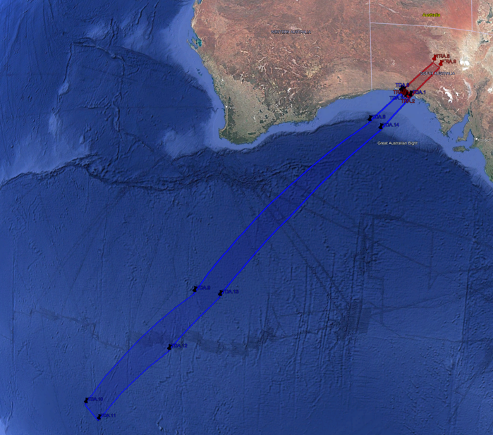
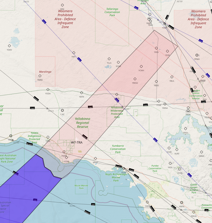
A TRA is to be declared from the surface (SFC) to unlimited altitude (UNL), conservatively encompassing the hazard area for the returning satellite within Australian territory. Aircraft will not be permitted to transit the TRA during the enforcement period. Airservices Australia will serve as the controlling authority for the TRA.
The TRA NOTAM will include suggested diversion routes. For reference, diversion routes from a previous satellite re-entry are provided below, noting that these may be revised for the W-7 re-entry pending final TRA/TDA coordinates:
|
W-7 Return Temporary Restricted Area (TRA) Coordinates |
||||
| Name |
Latitude (Decimal Deg) |
Longitude (Decimal Deg) |
Latitude (DD MM SS S) |
Longitude (DDD MM SS E) |
| TRA. 1 | -32.230630 | 132.347908 | 32° 13’ 50.27”S | 132° 20’ 52.47”E |
| TRA. 2 | -32.333555 | 132.190902 | 32° 20’ 00.80”S | 132° 11’ 27.25”E |
| TRA. 3 | -32.318069 | 132.020569 | 32° 19’ 05.05”S | 132° 01’ 14.05”E |
| TRA. 4 | -32.175736 | 131.888238 | 32° 10’ 32.65”S | 131° 53’ 17.66”E |
| TRA. 5 | -32.090861 | 131.739397 | 32° 05’ 27.10”S | 131° 44’ 21.83”E |
| TRA. 6 | -31.925502 | 131.696111 | 31° 55’ 31.81”S | 131° 41’ 46.00”E |
| TRA. 7 | -31.835755 | 131.523788 | 31° 50’ 08.72”S | 131° 31’ 25.64”E |
| TRA. 8 | -29.129391 | 134.481122 | 29° 07’ 45.81”S | 134° 28’ 52.42”E |
| TRA. 9 | -29.531750 | 135.0532 | 29° 31’ 54.30”S | 135° 03’ 11.73”E |
PERTH AD (YPPH) DEPARTURES/ARRIVALS JET TO/FROM EAST: VIA PUGUT PINAV KG
FOR INTERNATIONAL FLIGHTS TO ASIA AND MIDDLE EAST, A585 AND T20 ARE UNAVAILABLE (T21 REMAINS AVAILABLE).
Temporary Danger Area (TDA)
The TRA will be supplemented by a TDA, established to extend from the TRA further southwest over the Southern Ocean and encompass the hazard area beyond Australian territory, as defined by the 12-nautical-mile territorial sea boundary. The TDA will be active during the same period as the TRA, and aircraft operators are advised to plan around the area during this time. Airservices Australia will serve as the contact for the TDA.
|
W-7 Return Temporary Danger Area (TDA) Coordinates |
||||
| Name |
Latitude (Decimal Deg) |
Longitude (Decimal Deg) |
Latitude (DD MM SS S) |
Longitude (DDD MM SS E) |
| TDA. 1 | -32.230630 | 132.347908 | 32° 13’ 50.27”S | 132° 20’ 52.47”E |
| TDA. 2 | -32.333555 | 132.190902 | 32° 20’ 00.80”S | 132° 11’ 27.25”E |
| TDA. 3 | -32.318069 | 132.020569 | 32° 19’ 05.05”S | 132° 01’ 14.05”E |
| TDA. 4 | -32.175736 | 131.888238 | 32° 10’ 32.65”S | 131° 53’ 17.66”E |
| TDA. 5 | -32.090861 | 131.739397 | 32° 05’ 27.10”S | 131° 44’ 21.83”E |
| TDA. 6 | -31.925502 | 131.696111 | 31° 55’ 31.81”S | 131° 41’ 46.00”E |
| TDA. 7 | -31.835755 | 131.523788 | 31° 50’ 08.72”S | 131° 31’ 25.64”E |
| TDA. 8 | -34.254877 | 128.654502 | 34° 15’ 17.56”S | 128° 39’16.21”E |
| TDA. 9 | -45.458883 | 109.452816 | 45° 27’ 31.98”S | 109° 27’ 10.14”E |
| TDA.10 | -50.784441 | 089.510633 | 50° 47’ 03.99”S | 089° 30’ 38.28”E |
| TDA.11 | -52.461263 | 089.993025 | 52° 27’ 40.55”S | 089° 59’ 34.98”E |
| TDA.12 | -49.245677 | 104.411783 | 49° 14’ 44.44”S | 104° 24’ 42.42”E |
| TDA.13 | -46.158452 | 112.185138 | 46° 09’ 30.43”S | 112° 11’ 06.50”E |
| TDA.14 | -34.866125 | 129.634413 | 34° 51’ 58.05”S | 129° 38’ 03.89”E |