On this page
Closed consultation

Submit feedback to
ADF Airspace
Joint Airspace Control Cell
Defence
Joint Airspace Control Cell (JACC) requests feedback on a proposed temporary danger area (TDA) to be employed north of the Pearce military airspace to support defence flying training.
The issue
This proposal notes the following key issues:
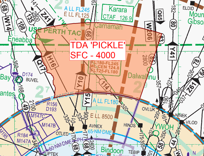
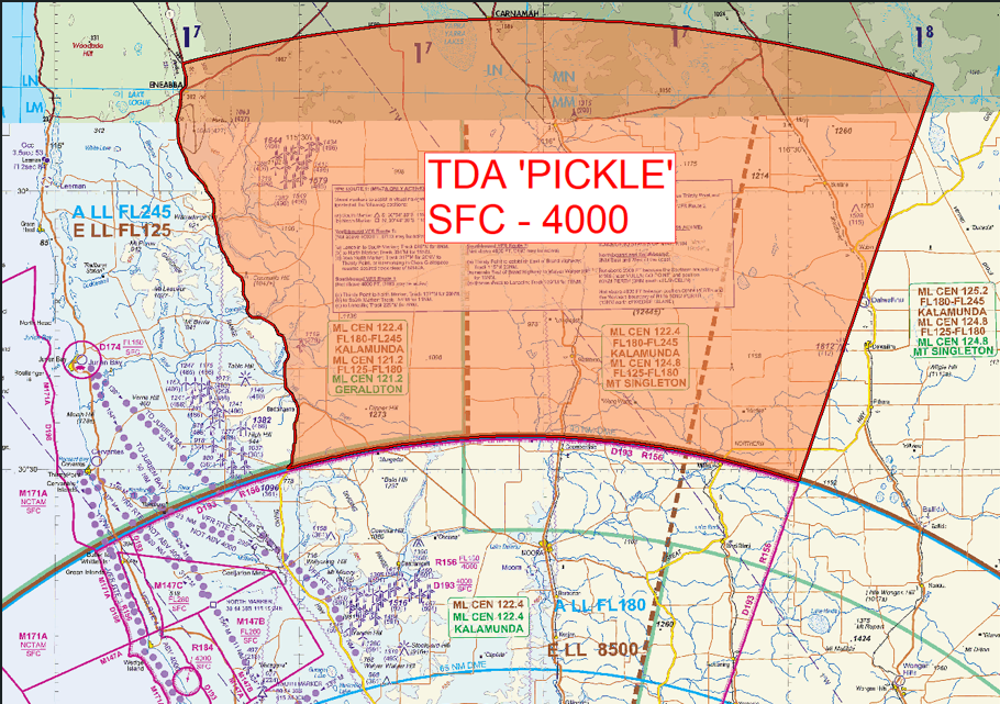
- Activation of proposed TDA ‘PICKLE’ to extend D193 on a temporary basis to support low level flying training
- The accumulation of low flying hazards (mining activity and wind-farm developments) in D193 have restricted low level flying training to the eastern portion of D193 where airspace can become relatively congested around Moora township and aerodrome, Moora airport (YMRO) Western Australia
- Proposed temporary airspace volume extending to 135 distance measuring equipment (DME) Perth bounded by the PH 019 VOR radial on the East and the Brand Highway on the West. Airspace designed to avoid the network of low-level visual flight rules (VFR) transit corridors around M147 (Lancelin air weapons range), and population centres/rural settlements which are more abundant near the coast.
Proposal
Defence seeks to raise awareness and increase safety for the aviation community with a TDA proposed to support low flying training outcomes for the Royal Australian Air Force.
Proposed dates for activation are listed in Table 1, with further details to be promulgated by Aeronautical Information Publication (AIP) supplements and Notice to Airmen (NOTAM).
|
TDA ‘PICKLE’ |
||
|
Start Date (Local) |
End Date (Local) |
Time (Local) |
|
22 September 2025 |
3 October 2025 |
NOTAM |
|
13 October 2025 |
31 October 2025 |
NOTAM |
YMMM/TDA ‘PICKLE’
Military Flying
Lateral Limits: 294618S 1151543E – then along the clockwise arc of a circle radius 135.00 nautical miles (n mile) centre 315642S 1155734E (PH/DME) – 294831S 1164749E – 303117S 1163119E – then along the counter clockwise arc of a circle radius 90.00 n mile centre 315642S 1155734E (PH/DME) – 303000S 1152836E then north along the Brand Highway – 294618S 1151543E
Vertical Limits: Surface (SFC) – 4000
Hours of Activity: Notice to airmen (NOTAM)
Controlling Authority: 452SQN Pearce Flight Commander
Aviation State Engagement Forum (AvSEF) members are invited to provide feedback to JACC: adf.airspace@defence.gov.au by 3 July 2025.