On this page
Closed consultation

Submit feedback to
Hamish
McNamara
Southern Launch Pty Ltd
To seek feedback on the proposed establishment of Temporary Restricted Areas (TRA) to support airspace safety during a suborbital rocket launch from the Koonibba Test Range (KTR) from 8 June to 15 June 2026.
The issue
- Suborbital rocket launch from the KTR.
- Declaration of TRAs to support airspace safety during suborbital rocket launch.
- Activation of a pre-TRA in hours leading up to the launch via Notice to Airmen (NOTAM) to ensure safe hazard area controls are in place to mitigate any potential off-nominal event.
- Activation of a launch TRA on target launch day(s) via NOTAM to ensure safe separation between aircraft and the rocket in flight.
- Airservices Australia to serve as the controlling authority for the launch TRA on target launch day(s). Coordination services and traffic routing to be provided by Melbourne Air Traffic Control.
Purpose
To seek feedback on the proposed establishment of TRA on multiple occasions to support airspace safety during suborbital rocket launch.
Proposal
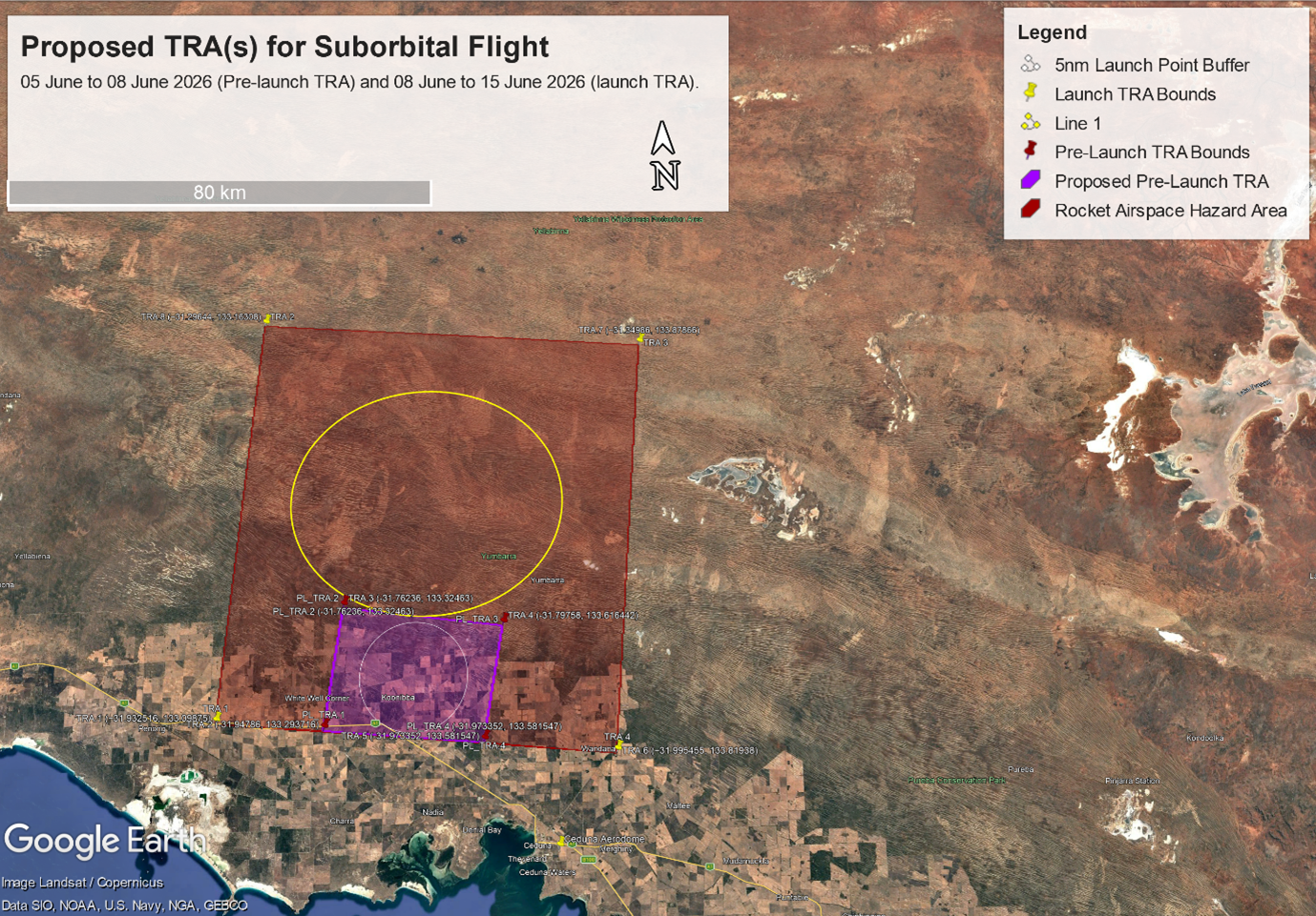
Southern Launch proposes to launch a suborbital rocket from the KTR, located in Koonibba SA, between 08th June to the 15th of June 2026. A pre-launch TRA would be active in the days prior to launch as a mitigation step for any potential off nominal events. This TRA would extend just over 6.5 nautical miles (NMs) (11.95kms) from the launch facility. In agreement with Airservices Australia, Southern Launch will serve as the controlling authority for the purposes of the pre-launch TRA.
The TRA supporting the launch would be activated on target launch days via NOTAM to ensure safe separation between aircraft and the rocket in flight.
The launch TRA, controlled by Airservices Australia will extend across all the planned launch trajectories, approximately 34NMs (62.9kms) northward to encompass the hazard area of the launch. Please refer to the below imagery and table showing the proposed boundaries for the TRA(s).
Table 1: Pre-Launch Temporary Restricted Area (TRA) Coordinates05 June-08 June 2026 |
||||
Name |
Latitude (Decimal Deg) |
Longitude (Decimal Deg) |
Latitude (DD MM SS S) |
Longitude (DDD MM SS E) |
|
PL_TRA.1 |
-31.94786 |
133.293716 |
31°56'52.30"S |
133°17'37.38"E |
|
PL_TRA.2 |
-31.76236 |
133.32463 |
31°45'44.50"S |
133°19'28.67"E |
|
PL_TRA.3 |
-31.79758 |
133.616442 |
31°47'51.29"S |
133°36'59.19"E |
|
PL_TRA.4 |
-31.973352 |
133.581547 |
31°58'24.07"S |
133°34'53.57"E |
Table 2: Launch Temporary Restricted Area (TRA) Coordinates08 June-15 June 2026 |
||||
Name |
Latitude (Decimal Deg) |
Longitude (Decimal Deg) |
Latitude (DD MM SS S) |
Longitude (DDD MM SS E) |
|
TRA.1 |
−31.932516 |
133.09875 |
31°55'57.06"S |
133° 5'55.53"E |
|
TRA.2 |
-31.94786 |
133.293716 |
31°56'52.30"S |
133°17'37.38"E |
|
TRA.3 |
-31.76236 |
133.32463 |
31°45'44.50"S |
133°19'28.67"E |
|
TRA.4 |
-31.79758 |
133.616442 |
31°47'51.29"S |
133°36'59.19"E |
|
TRA.5 |
-31.973352 |
133.581547 |
31°58'24.07"S |
133°34'53.57"E |
|
TRA.6 |
−31.995455 |
133.81938 |
31°59'43.64"S |
133°49'9.77"E |
|
TRA.7 |
−31.34986 |
133.87866 |
31°20'59.53"S |
133°52'43.21"E |
|
TRA.8 |
−31.29644 |
133.16308 |
31°17'47.20"S |
133° 9'47.12"E |
Related links
A Shapefile for these areas can be made available upon request. Southern Launch will aim to minimise the effect of airspace restrictions on other airspace users while ensuring that the launch activity is conducted safely. Launch schedule updates will be published on Southern Launch's website in the lead up to the launch period:
https://www.southernlaunch.space/upcoming-missions
Southern Launch welcomes feedback from the forum members on any impact that the proposed TRA may have on planned operations in the region during the launch period.