On this page
Closed advisory

Submit feedback to
Eamon
Lawson
Southern Launch
Notice of a revised activation timing and boundary extents for the TRA/TDA supporting the W-6 satellite re-entry between 7 May and 15 July 2026.
Purpose
As an update to the prior consultation, Southern Launch advises that the activation timing and boundary extents for the Temporary Restricted Area (TRA) and Temporary Danger Area (TDA) supporting the W‑6 satellite re-entry have been refined.
The TRA/TDA are expected to be activated between 05:50 and 06:50 UTC, in support of a return scheduled to occur between 7 May and 15 July 2026. The final TRA/TDA boundaries are provided below and have been safely truncated from those presented in the original consultation.
Ceduna Airport (YCDU) remains encompassed by the TRA and will be temporarily closed for the duration of activation. Final activation timings and diversionary routing will be promulgated by NOTAM approximately one week prior to the return.
The NOTAM may span across multiple consecutive contingency days and will be stood down upon the safe completion of the activity. Stakeholders are encouraged to continue contacting Southern Launch with any feedback or questions relating to this activity or the proposed airspace management solution.
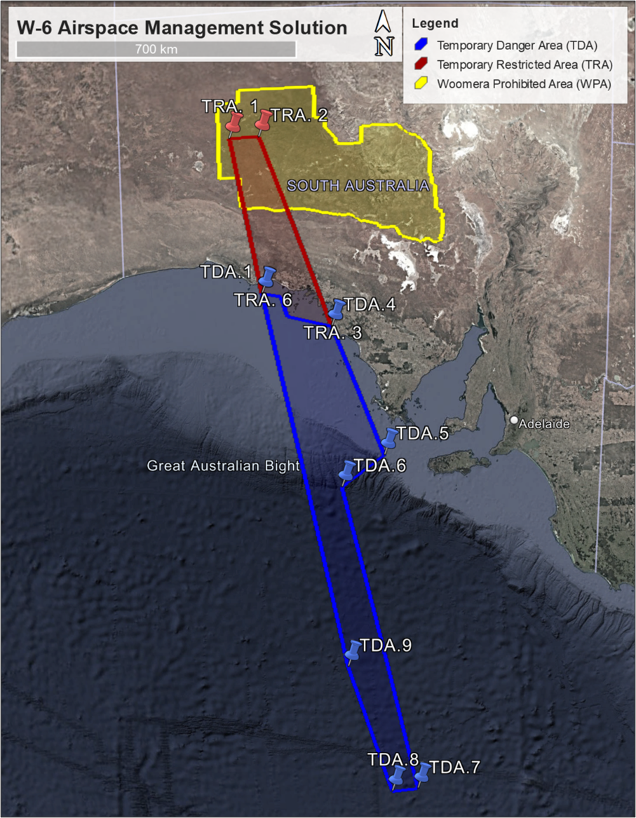
Airspace Management Solution
W-6 Satellite Re-entry to the Koonibba Test Range
Active on notified occasions between 7 May and 15 June 2026
|
W-6 Return Temporary Restricted Area (TRA) Coordinates |
||||
|---|---|---|---|---|
|
Name |
Latitude (Decimal Deg) |
Longitude (Decimal Deg) |
Latitude (DD MM SS S) |
Longitude (DDD MM SS E) |
|
TRA. 1 |
-28.886587 |
131.771844 |
28° 53' 11.71'' S |
131° 46' 18.64'' E |
|
TRA. 2 |
-28.889806 |
132.489523 |
28° 53' 23.30'' S |
132° 29' 22.28'' E |
|
TRA. 3 |
-32.973041 |
134.165775 |
32° 58' 22.95'' S |
134° 09' 56.79'' E |
|
TRA. 4 |
-32.738488 |
133.077203 |
32° 44' 18.56'' S |
133° 04' 37.93'' E |
|
TRA. 5 |
-32.313937 |
132.934505 |
32° 18' 50.17'' S |
132° 56' 04.22'' E |
|
TRA. 6 |
-32.233228 |
132.46212 |
32° 13' 59.62'' S |
132° 27' 43.63'' E |
|
W-6 Return Temporary Danger Area (TDA) Coordinates |
||||
|---|---|---|---|---|
|
Name |
Latitude (Decimal Deg) |
Longitude (Decimal Deg) |
Latitude (DD MM SS S) |
Longitude (DDD MM SS E) |
|
TDA. 1 |
-32.233228 |
132.46212 |
32° 13' 59.62'' S |
132° 27' 43.63'' E |
|
TDA. 2 |
-32.313937 |
132.934505 |
32° 18' 50.17'' S |
132° 56' 04.22'' E |
|
TDA. 3 |
-32.738488 |
133.077203 |
32° 44' 18.56'' S |
133° 04' 37.93'' E |
|
TDA. 4 |
-32.973041 |
134.165775 |
32° 58' 22.95'' S |
134° 09' 56.79'' E |
|
TDA. 5 |
-35.661592 |
135.424155 |
35° 39' 41.73'' S |
135° 25' 26.96'' E |
|
TDA. 6 |
-36.311987 |
134.320245 |
36° 18' 43.15'' S |
134° 19' 12.88'' E |
|
TDA. 7 |
-42.781824 |
136.217284 |
42° 46' 54.57'' S |
136° 13' 02.22'' E |
|
TDA. 8 |
-42.840831 |
135.476883 |
42° 50' 26.99'' S |
135° 28' 36.78'' E |
|
TDA. 9 |
-40.092153 |
134.337474 |
40° 05' 31.75'' S |
134° 20' 14.91'' E |