 Aviation State Engagement Forum
On this page
Open consultation

Submit feedback to
Jason
Milne
Southern Launch
Proposed Temporary Restricted Area (TRA) and Temporary Danger Area (TDA) active for ~60 minutes within 12:15–16:15 UTC between 01 Nov and 31 Dec 2026 to support the W-8 and W-9 satellite re-entries.
The issue
W-8 and W-9 satellite re-entries to Koonibba Test Range, SA. The declaration of a large TRA and TDA to support safe separation during a period of approximately 60 minutes within 12:15–16:15 UTC on two or more occasions between 01 November and 31 December 2026.
The TRA/TDA boundary provided is indicative only and is to be further refined in mid-Sept 2026. The TRA is expected to encompass the Ceduna Aerodrome (YCDU) and result in a temporary closure of the airport for the duration of the NOTAM. Restrictions are also proximate to, but are not expected to encompass, the Streaky Bay Aerodrome (YKBY) and the Jacinth Ambrosia Airstrip (YJAC). Final TRA/TDA boundary to be disseminated by AvSEF Advisory Notice and included in the activity NOTAMs.
Purpose
To seek feedback on a TRA and TDA to support the W-8 and W-9 satellite re-entries to the Koonibba Test Range, South Australia (SA). Airspace declarations propose to be active for approximately 60 minutes within 12:15–16:15 UTC on two or more occasions between 01 November and 31 December 2026.
Proposal
Airspace controls will be activated on notified occasions for approximately 60 minutes within 12:15–16:15 UTC for each satellite’s return.
Wherever practicable, Southern Launch will ensure that NOTAMs are published at least 5 days in advance, specifying exact dates and times of activation. Daily windows for the same time across multiple dates may be included to accommodate potential backup days and will be stood down upon successful completion of the activity.
Temporary Restricted Area:
A TRA is defined from the surface (SFC) to unlimited (UNL), encompassing the hazard area for the returning satellites within Australian territory. Aircraft will not be permitted to operate in the TRA during the activation periods. The TRA does not encompass Ceduna Airport (YCDU) however users of YCDU should note the proximity of the TRA to YCDU. The TRA does encompass portions of the YCDU Instrument Approach Procedures which may impact on IFR operations to YDCU during the TRA activation periods. Airspace users should also note the proximity of the TRA to Streaky Bay (YKBY) and Jacinth Ambrosia (YJAC) aerodromes. Airservices Australia will serve as the controlling authority for the TRA.
Southern Launch will notify local operators of any access restrictions following consultation with CASA and Airservices Australia regarding requisite separation standards and will coordinate with aerodrome operators to publish an AD NOTAM if required. The TRA NOTAM will include suggested diversionary routes. For reference, diversionary advice from a previous satellite re-entry is provided below, noting that these may be revised for the W-8 and W-9 re-entries pending final TRA/TDA coordinates:
PERTH AD (YPPH) DEPARTURES/ARRIVALS JET TO/FROM EAST: VIA PUGUT PINAV KG
FOR INTERNATIONAL FLIGHTS TO ASIA AND MIDDLE EAST, A585 AND T20 ARE UNAVAILABLE (T21 REMAINS AVAILABLE).
Temporary Danger Area:
The TRA will be supplemented by a TDA, established to extend from the TRA further southward over the ocean and encompass the hazard area beyond Australian territory, as defined by the 12-nautical-mile territorial sea boundary. The TDA will be active during the same period as the TRA, and aircraft operators are advised to plan around the area during this time. Airservices Australia will serve as the contact for the TDA. Boundary and Timing The boundaries of the TRA/TDA provided in the attachment are conservative assumptions for consultation purposes only. Final TRA/TDA boundaries will be refined in mid-Sept 2026 and published as AvSEF Advisory Notice, alongside a timeline update for the return. Final activation timings and TRA/TDA boundaries will be published in the activity NOTAMs. Contact Please contact Southern Launch at the details below to request direct updates on mission timings, a shapefile of the hazard areas, or to provide feedback on this proposal.
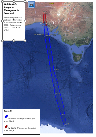
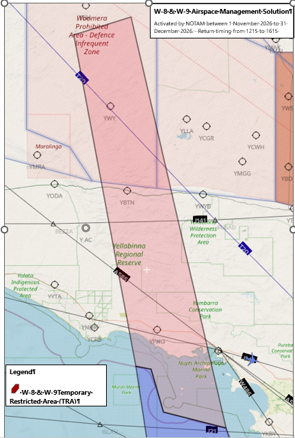
Airspace Management Solution
W-8 and W-9 Satellite Re-entries to the Koonibba Test Range
Active on notified occasions between 01 November and 31 December 2026
|
W-8 & W-9 Temporary Restricted Area (TRA) Coordinates |
||||
|---|---|---|---|---|
|
Label |
Lat (Degrees) |
Lon (Degrees) |
Lat (DMS) |
Long (DMS) |
|
TRA.1 |
-28.936102 |
132.044357 |
28° 56' 09.97'' S |
132° 02' 39.69'' E |
|
TRA.2 |
-28.751558 |
132.703762 |
28° 45' 05.61'' S |
132° 42' 13.54'' E |
|
TRA.3 |
-32.894936 |
133.797366 |
32° 53' 41.77'' S |
133° 47' 50.52'' E |
|
TRA.4 |
-32.738488 |
133.077203 |
32° 44' 18.56'' S |
133° 04' 37.93'' E |
|
TRA.5 |
-32.313937 |
132.934505 |
32° 18' 50.17'' S |
132° 56' 04.22'' E |
|
TRA.6 |
-32.284021 |
132.759435 |
32° 17' 02.48'' S |
132° 45' 33.97'' E |
|
W-8 & W-9 Temporary Danger Area (TDA) Coordinates |
||||
|
Label |
Lat (Degrees) |
Long (Degrees) |
Lat (DMS) |
Long (DMS) |
|
TDA.1 |
-32.284021 |
132.759435 |
32° 17' 02.48'' S |
132° 45' 33.97'' E |
|
TDA.2 |
-32.313937 |
132.934505 |
32° 18' 50.17'' S |
132° 56' 04.22'' E |
|
TDA.3 |
-32.738488 |
133.077203 |
32° 44' 18.56'' S |
133° 04' 37.93'' E |
|
TDA.4 |
-32.894941 |
133.797365 |
32° 53' 41.79'' S |
133° 47' 50.51'' E |
|
TDA.5 |
-36.319417 |
135.076587 |
36° 19' 09.90'' S |
135° 04' 35.71'' E |
|
TDA.6 |
-47.146056 |
138.323422 |
47° 08' 45.80'' S |
138° 19' 24.32'' E |
|
TDA.7 |
-64.784036 |
147.71726 |
64° 47' 02.53'' S |
147° 43' 02.14'' E |
|
TDA.8 |
-65.408965 |
146.50346 |
65° 24' 32.27'' S |
146° 30' 12.46'' E |
|
TDA.9 |
-61.672281 |
143.474478 |
61° 40' 20.21'' S |
143° 28' 28.12'' E |
|
TDA.10 |
-54.91999 |
139.422562 |
54° 55' 11.96'' S |
139° 25' 21.22'' E |
|
TDA.11 |
-36.685136 |
133.547315 |
36° 41' 06.49'' S |
133° 32' 50.33'' E |
Related links
https://www.southernlaunch.space/upcoming-missions